San Francisco Peaks
San Francisco Peaks Geology
By Bill Wade – a geologist and a 12-year member of Flagstaff’s USFS/NPS Interpretive Partnership.
Introduction: The San Francisco Peaks are the eroded remains of a single, once-much-higher, stratovolcano called San Francisco Mountain (‘SFM’). Stratovolcanoes are large conical volcanoes composed of many alternating layers of hardened lava, and looser tephra (cinders, and larger volcanic “bombs”), plus pumice and ash, deposited during multiple eruptions, typically over millions of years.
The geologic map below shows—in shades of purples and greens—the major lava flows that radiated outward and downward on all the flanks of SFM, with the different hues distinguishing the different ages and mineral compositions of the flows.
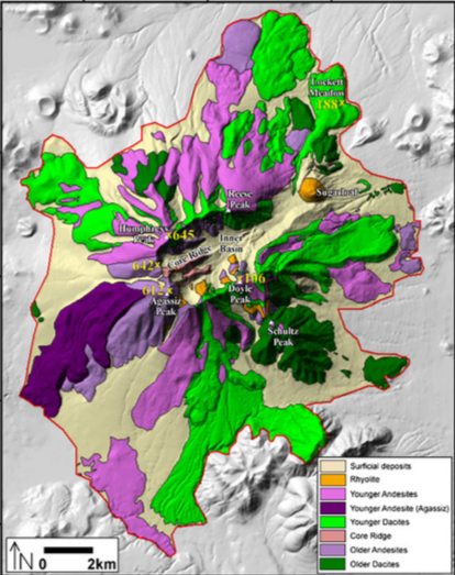
Simplified geology of the San Francisco Peaks, after Holm (1988), from Karatson et al. (2010).
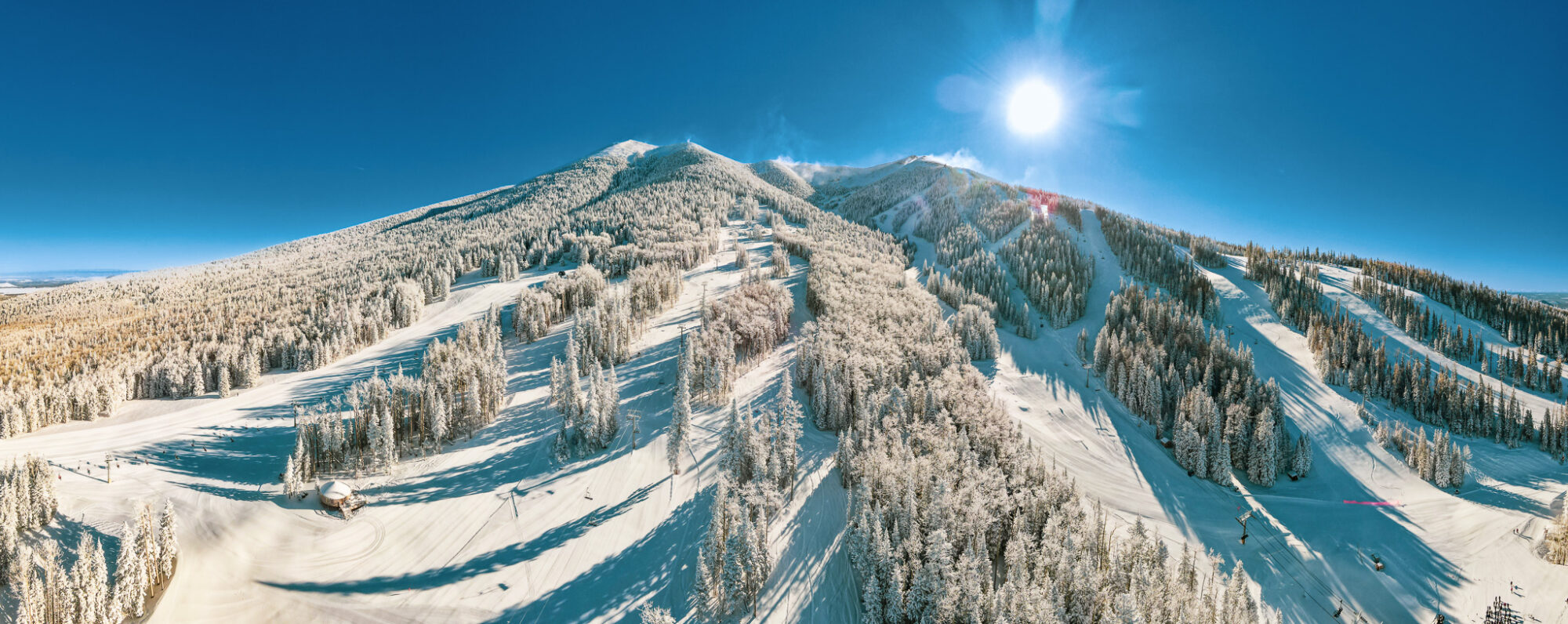
Because lava-flow rock is dense and resistant to erosion, the lava flows form the ridges we can see today on the flanks of SFM. Areas between lava-flow ridges were surfaced predominantly by looser cinder and ash deposits, and consequently, these have eroded fairly deeply between the ridges. The “Bowl” of Arizona Snowbowl—shown as a light tan triangular area on the middle left of the map above—on the west flank between Mt. Agassiz and Mt. Humphrys, is an excellent example of one such eroded inter-ridge area. So the Bowl is not, as some assume, a crater of the volcano: the true crater was on the far side of the ridgeline high above Arizona Snowbowl’s ski runs.
Timing of Eruptions: The SFM volcanic cone was constructed by multiple eruptions between 900,000 and 400,000 years ago. These can be grouped into three major eruptive stages, separated by long periods of quiescence. It’s probable that volcanic rocks a bit older than 900k lie buried beneath SFM, where they can’t be sampled and dated. In round numbers, it’s accurate enough to say that SFM dates back as far as 1 million years, and became dormant 400k years ago.
Collapse of SFM’s Top and NE Flank: Sometime between the end of the last major eruptions 400k years ago, and the eruption of Sugarloaf lava dome volcano 92k years ago, the top and northeast flank of SFM collapsed in a gigantic avalanche that spilled outward toward the northeast. In the geologic map above, you can see the central portion of SFM—mainly colored light tan—as a roughly circular area labelled “Inner Basin”. This is a deeply eroded valley, where the topmost portion of SFM once stood (see figure below). The purple and green lava flows on the map, for the most part, originated from this high central zone, but the tops of these flows collapsed as part of the avalanche. You can see that the light tan of the Inner Basin extends toward the NE, interrupted only by Sugarloaf lava dome, depicted by an orange circular area in the middle of the northeastward light tan, which represents the upper portion of the avalanche deposit. Because Sugarloaf occupies part of the area evacuated by the avalanche, its eruption (dated at 92k years ago) necessarily postdates the volcano’s northeastward collapse.
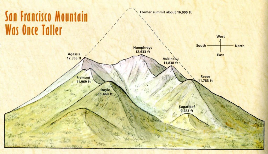
View of SFM from the east, showing the Inner Basin (previously the highest part of the stratovolcano, the 6 peaks that now rim the Inner Basin, and Sugarloaf, a younger lava dome that was emplaced after the top and NE side of SFM had collapsed in a gigantic avalanche. After Duffield (1997).
The simple sketch above depicts the former top of SFM as high as 16,000ft. However, the most recent and scientifically rigorous study of the pre-collapse SFM, based on measurements of slope angles of uneroded portions of the mountain’s flanks (see figure below) suggests that there were two distinct vents up on top of the volcano back when SFM was at its tallest.
Projections from the southern half of the mountain point to a Southern Cone that topped out at 4350 meters (14,272 ft) (see figure below). The Southern Cone’s lava flows (including The Ridge ski run, which begins right at the top of the Agassiz chairlift—AKA the Scenic Chairlift—of today’s Arizona Snowbowl) ceased erupting while the Northern Cone was still erupting and growing taller. The Northern Cone erupted longer and built up higher, in part by piling atop the older Southern Cone. This tip-top vent is calculated to have reached an altitude of 4460 meters (14,633 ft). Note that these two ancient vents mirror the two highest peaks we see today: Mt. Agassiz (12,356ft today), the second-highest peak, lies further south and is capped by older lava flows from the Southern Cone, while #1 Mt. Humphreys (12,633ft today), sits a bit further north and is topped by the youngest lava flows on SFM, which came from the Northern Cone. Note that, at 14,633ft, the Northern Cone was exactly 2000ft higher than today’s Mt. Humphreys. Purely for our convenience, no doubt!
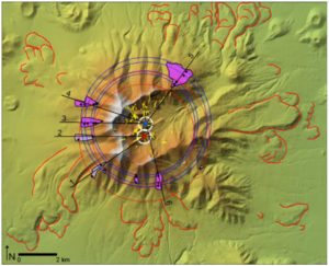
Projections from un-eroded slope areas (purple) on the flanks of SFM point to 2 vents at the top of the volcano before its collapse, the Northern Cone vent shown as a blue dot, the somewhat lower Southern Cone as a red dot. From Karatson et al. (2010).
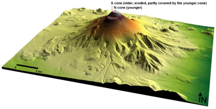
The latest and most scientific reconstruction of SFM prior to its northeastward collapse. The Southern Cone was older, the Northern Cone a bit younger, and topped out higher, at 14,633 ft.
Competing Theories: In the years that shortly followed the notorious “sideways eruption” of Mount St. Helens in Washington state in 1980 (see computer model graphic of this event below), the collapse of the top and northeast flank of SFM was interpreted by a number of local geologists as having occurred during a similar “sideways eruption”.
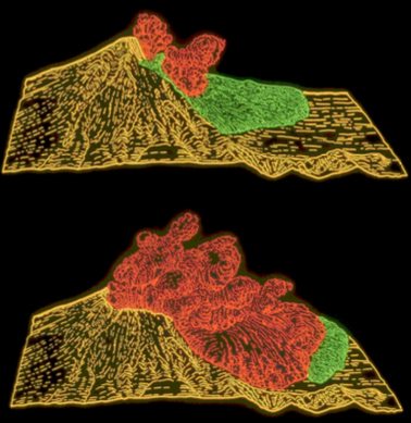
Computer graphic depictions of the May 18, 1980 eruption of Mount St. Helens. The landslide (green) is quickly overtaken by the initial airborne pyroclastic flow (green). Courtesy US Geologic Survey.
Although this idea was attractive, to date no hard geologic evidence has been found that directly supports the occurrence of the final eruptions of SFM being simultaneous with, and triggering, the northeastward collapse of the mountain. Absent such evidence, the avalanche more likely occurred as a “cold” landslide, unconnected to any eruptive event. Geologists have determined from many detailed studies that many stratovolcanoes around the world have grown unstable and partially collapsed, without the involvement of simultaneous eruptions. The asymmetry resulting from having two major vents atop SFM, instead of a single, symmetrical vent, may well have contributed to the instability that led to the volcano’s collapse.
SFM Post-Collapse and Today: A great deal of erosion has taken place in the Inner Basin since the east side of SFM collapsed. Over the last 2.6 million years, there have been 13 major continental glaciations (“Ice Ages”), each accompanied by growth and expansion of mountain glaciers, including on SFM. During the last 1–3 Ice Ages, the Inner Basin would have been occupied each time by an Inner Basin Glacier. Today, glacial rock deposits (“moraines”) left behind by the Inner Basin Glaciers are still readily visible in the Inner Basin. Hey!—you could have skied “Arizona Snowbowl East” year-round 20,000 years ago, but watch out for those deep crevasses!
And finally, not only can you see what remains of SFM today, you can also still see portions of the huge avalanche deposit that were created when the top and northeast flank of the mountain came tumbling down. The avalanche came to rest as an gee-normous semi-circular deposit, highest and thickest up close to the volcano, and sloping and thinning gradually downward to a feather edge several miles out to the east and northeast. The portion of this semicircular cone of debris that came to lie directly east of SFM was subsequently covered by younger volcanoes (O’Leary, Sunset Crater, the Cinder Hills, etc.) that erupted through the avalanche deposit, aplusnd their lava flows which spilled out across the surface of the avalanche material. However, when you drive north along US 89 toward Gray Mountain and Cameron, beginning about 1 mile north of the turnoff to Lockett Meadow (on the left) and Sunset Crater Volcano Nat’l Monument (on the right), you will find yourself driving continuously downhill for a long 3 miles, descending a very consistent 6% grade. You are riding down the sloping top surface of the giant avalanche deposit, which was formerly the top and northeast flank of SFM.
San Francisco Volcanic Field: And finally, San Francisco Mountain is by no means alone as a volcano in our vicinity. SFM lies roughly in the center of a larger volcanic field, which is dotted with more than 600 volcanoes (see figure below), ranging in size from the relatively small cinder cones, through the medium-size lava domes, up to the one and only stratovolcano, SFM. Generally, eruptive activity within the field has generally shifted slowly from west to east over the last 6 million years. Directional movement like this in other areas (the Hawaiian Islands, for example) is very well understood as resulting from the movement of tectonic plates over the Earth’s surface, while a Hot Spot lies stationary below. But this sort of hot spot explanation is not a suitable model for the eastward progression of volcanic activity in the SF Volcanic Field. There are too many similar, relatively small volcanic fields in our region, including the Western Grand Canyon field, the Mormon Lake field, and other volcanic fields that extend into New Mexico. The multiplicity of volcanic fields cannot be credited to a multiplicity of hot spots, or to the effects of a single large hot spot. So rather than being related to movement over a hot spot, the origin of these several volcanic fields must somehow be related to the uplift of this, the southwestern edge of the Colorado Plateau. But we geologists don’t have an accepted theory to explain why the Colorado Plateau has risen the way it has over the last 30 million years, and until we understand that, we probably won’t be able to explain the origin of the several volcanic fields in our region that are one piece of that larger puzzle.
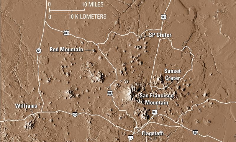
Digital Elevation Map of the San Francisco Volcanic Field. Although SFM, as the field’s only stratovolcano, is by far the largest volcano in the field, there are more than 600 other volcanoes surrounding it, the larger ‘bumps’ being lava domes, and the numerous smaller ones being cinder cones, including the most recent, Sunset Crater volcano (erupted ~940 years ago). Courtesy US Geological Survey.
San Francisco Mountain hasn’t erupted in the last 400k years, and we can therefore be confident that it is not merely dormant, it’s dead. But that doesn’t mean that the San Francisco Volcanic Field is dead; it’s only temporarily dormant. The last eruption in the field was the Sunset Crater cinder cone, some 940 years ago; there will be more eruptions in the SF Volcanic Field in the future. Stay tuned!
_______________________
Bill Wade is a geologist and a 12-year member of Flagstaff’s USFS/NPS Interpretive Partnership. Members of the Partnership provide interpretive programs and Q&A for Snowbowl visitors at the top of the scenic gondola every weekend throughout the summer months.
